

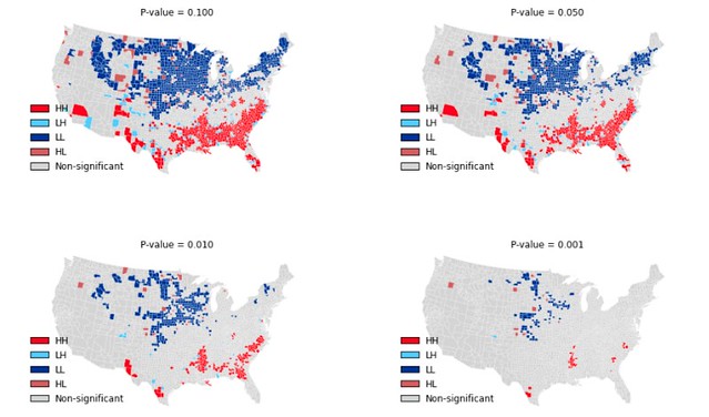
Above: Local Indicators of Spatial Association for Homicide Rates in US Counties 1990.
PySAL, the Python spatial analysis library, is an open source cross-platform library for geospatial data science with an emphasis on geospatial vector data written in Python. It supports the development of high level applications for spatial analysis, such as
- detection of spatial clusters, hot-spots, and outliers
- construction of graphs from spatial data
- spatial regression and statistical modeling on geographically embedded networks
- spatial econometrics
- exploratory spatio-temporal data analysis
- explore - modules to conduct exploratory analysis of spatial and spatio-temporal data, including statistical testing on points, networks, and polygonal lattices. Also includes methods for spatial inequality, distributional dynamics, and segregation.
- viz - visualize patterns in spatial data to detect clusters, outliers, and hot-spots.
- model - model spatial relationships in data with a variety of linear, generalized-linear, generalized-additive, and nonlinear models.
- lib - solve a wide variety of computational geometry problems:
- graph construction from polygonal lattices, lines, and points.
- construction and interactive editing of spatial weights matrices & graphs
- computation of alpha shapes, spatial indices, and spatial-topological relationships
- reading and writing of sparse graph data, as well as pure python readers of spatial vector data.
PySAL is available through Anaconda (in the defaults or conda-forge channel) We recommend installing PySAL from conda-forge:
conda config --add channels conda-forge
conda install pysal
PySAL can also be installed using pip:
pip install pysal
As of version 2.0.0 PySAL has shifted to Python 3 only.
Users who need an older stable version of PySAL that is Python 2 compatible can install version 1.14.3 through pip or conda:
conda install pysal==1.14.3
For help on using PySAL, check out the following resources:
As of version 2.0.0, PySAL is now a collection of affiliated geographic data science packages. Changes to the code for any of the subpackages should be directed at the respective upstream repositories, and not made here. Infrastructural changes for the meta-package, like those for tooling, building the package, and code standards, will be considered.
Development is hosted on github.
Discussions of development as well as help for users occurs on the developer list as well as gitter.
If you are interested in contributing to PySAL please see our development guidelines.
To search for or report bugs, please see PySAL's issues.
To build the meta-package pysal see build.md.
See the file "LICENSE.txt" for information on the history of this software, terms & conditions for usage, and a DISCLAIMER OF ALL WARRANTIES.