
This repository contains airspace data for the V-LARA system.
If you'd like to add a new FIR (Cluster), please follow the steps below.
You will need to create two files named after your FIR (replace xxxx with the FIR name in lowercase):
xxxx.geojson– for airspace geometryxxxx.json– for FIR configuration
This file should follow the GeoJSON format and define each airspace volume as a Feature.
- You can easily convert TopSkyAreas.txt files into V-LARA GeoJSON format using the Converter Tool
- After converting, please check the file manually. Only reservable areas shall be included!
- You can check the validity of the V-LARA GeoJSON file using the Data Quality Tool
{
  "type": "FeatureCollection",
  "features": [
    {
      "type": "Feature",
      "properties": {
        "name": "TSA1",
        "type": "TSA",
        "upperFL": 660,
        "lowerFL": 95
      },
      "geometry": {
        "type": "Polygon",
        "coordinates": [
          [
            [27.1153, 57.7875],
            [26.5861, 57.6333],
            [26.1611, 57.9083],
            [25.2217, 58.2014],
            [25.2222, 58.2736],
            [25.7456, 58.3797],
            [26.75, 58.3667],
            [27.1675, 57.9175],
            [27.1153, 57.7875]
          ]
        ]
      }
    },
    {
      "type": "Feature",
      "properties": {
        "name": "TSA2",
        "type": "TSA",
        "upperFL": 245,
        "lowerFL": 95,
        "mustBeBookedWith": ["TSA1"],
        "activationLimits": [
          {"time": ["0900", "2000"], "month": [1, 2, 3, 4, 5, 6, 7, 8, 9, 10, 11, 12], "weekday": [1, 2, 3, 4, 5, 6, 7]},
          {"time": ["2000", "2200"], "month": [1, 2, 3, 4, 5, 6, 7, 8, 9, 10, 11, 12], "weekday": [1, 2, 3, 4, 5]}
        ]
      },
      "geometry": {
        "type": "Polygon",
        "coordinates": [
          [
            [23.2075, 59.1261],
            [24.2236, 59.3049],
            [24.2611, 59.2283],
            [23.4333, 58.9],
            [23.2075, 59.1261]
          ]
        ]
      }
    }
  ]
}Each Feature must contain the following fields inside its properties object:
| Field | Type | Description |
|---|---|---|
name |
string | airspace name (e.g., "TSA1"). The airspace must match with the name in TopSky areas.txt! |
type |
string | Type of airspace (e.g., "TSA", "Local TRA"). Keep the type as short as possible. |
lowerFL |
number | Lower flight level (e.g., SFC → 0. 500FT → 5. 9500FT → 95) |
upperFL |
number | Upper flight level (e.g., 10700 FT → 107. UNL → 999) |
(mustBeBookedWith) |
array | Optional list of airspace names that must be booked together or prior (e.g., ["TSA1", "TSA2"]) |
(activationLimits) |
array | Optional list of time + month + weekday limitations (see example json above) |
(foreignClusters) |
array | Optional list of fir codes in lower case (e.g., ["efin"]) - check information below! |
Make sure that:
- Each airspace has a distinct
nameand it shall match with TopSky areas.txt. - Note! If you leave the name empty
"name": "", the shape will be visible on the map but not as a reservable airspace. This might be useful in order to display country borders etc. - Coordinates are listed in the
[longitude, latitude]format. - The polygon is closed — the first and last coordinate pairs should match.
Cross-Border areas (optional):
- If the area is located near FIR borders, and both parties require details of the same airspace, add the following line to the airspace properties:
"foreignClusters": ["efin"]→ Helsinki FIR will also get the details of this airspace- The areas may be added into the geojson of the other FIR either as
"name": ""(not reservable) or with the same name as in the parent FIR (reservable in both FIRs) - Currently only the FIR creating the reservation will receive the automatic TopSky activation
- Make sure the airspace name matches in both FIRs TopSky areas.txt
This file defines how the FIR is displayed in the app and how airspaces are grouped.
{
  "mapCenter": [24.3, 58.5510],
  "mapZoom": 5.4,
  "pilotDocs": "https://wiki.vatsim-scandinavia.org/books/finnish-airports-charts/page/v-lara-airspace-reservation",
  "groups": {
    "GROUP1": {
      "airspaces": ["TSA1", "TSA2"],
      "lowerFL": 30,
      "upperFL": 999
    }
  }
}| Field | Type | Description |
|---|---|---|
mapCenter |
[number, number] |
Map center [longitude, latitude] for the default view |
mapZoom |
number |
Initial zoom level (e.g., 5.4) |
(pilotDocs) |
string |
Optional URL to local procedures for Area Reservations |
groups |
object |
A collection of airspace groups for organizing layers and filtering |
Each entry in the groups object defines a preset selection of many airspace blocks. This makes it faster for the user to select commonly grouped airspace selections.
Each group includes:
| Field | Type | Description |
|---|---|---|
airspaces |
string[] |
A list of airspace names that belong to this group |
(lowerFL) |
number |
Optional Group Lower FL (e.g., 30) - applies to all areas in group |
(upperFL) |
number |
Optional Group Upper FL (e.g., 999) - applies to all areas in group |
Make sure that the airspaces name's matches with the names defined in the .geojson file.
Example with multiple groups:
{
  "mapCenter": [24.3, 58.5510],
  "mapZoom": 6,
  "groups": {
    "TRIDENT": {
      "airspaces": ["TSA1", "TSA2"],
      "lowerFL": 0,
      "upperFL": 245
    },
    "POKKA": {
      "airspaces": ["TSA3", "TSA4", "TRA87W"]
    }
  }
}
If your FIR does not have grouped airspace reservations:
{
  "mapCenter": [24.3, 58.5510],
  "mapZoom": 6,
  "groups": {
    "No Presets": {
      "airspaces": [""]
    }
  }
}Before submitting a Pull Request, ensure:
- Each airspace
Featurein your.geojsonhas a uniquenameand the name matches with an airspace defined in TopSky areas.txt. - All
names in your.jsonfile’sgroups.airspacesarray match exactly with thenamevalues in your.geojson - Your
.geojsonfile is valid GeoJSON (you can use geojson.io or geojsonlint.com to validate) - Polygons in the
.geojsonare properly closed (i.e. the first and last coordinate pair are the same) - Your
.jsonfile is valid JSON (no trailing commas, properly quoted strings, etc.) - Flight levels (
lowerFLandupperFL) are correct -
mapCenterandmapZoomare appropriate to display the full FIR area. You may login to V-LARA profileEACCZAMC (test environment)to view boundaries of different FIR's. The coordinates are shown in the top-right corner of the Map Display.
After submitting and Approved Pull Request:
- Navigate to lara-backend.lusep.fi/topsky/xxxx.txt (replace xxxx with your FIR code)
- The file shows all currently ongoing reservations. By default it includes a dummy reservation
VLARA:350101:350101:0:1000:1001:0:100:VLARA:. This makes sure that TopSky is able to read the file at all times even when no reservations are present. - Navigate to plugins/
TopSkySettings.txtand add the following details:HTTP_Areas_Remote_URL=https://lara-backend.lusep.fi/topsky/xxxx.txtAreas_PreActiveTime=900use at least 900s (15min)
- For automatic area loading, the
Airspace Management Windowshall be set to open automatically on startup
The Cluster Housekeeping window is visible for VATSIM users with assigned National Housekeeper role in V-LARA.
This role can be requested from the V-LARA developer and additional users may be added via the Cluster Housekeeping window by any housekeeper.
National Housekeepers may change the following settings:
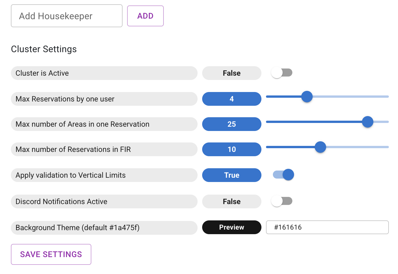
- To apply changes, click on the
SAVE SETTINGSbutton
You may contact me on Discord for any questions.