-
|
Hello, Thanks |
Beta Was this translation helpful? Give feedback.
Replies: 3 comments 10 replies
-
|
Hi @fzanst At the moment that feature (support physical groups) is not available. Having said that, I would probably create a CDB file for each group, and then import them one by one and assign them component selections at the same time you import them. |
Beta Was this translation helpful? Give feedback.
-
|
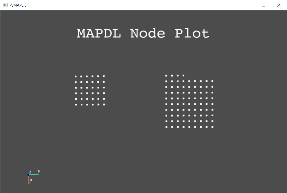
Hello @germa89, I have tried to solve my issue but not been able to. I have created a minimal example where I import two CDB files of meshed square planes (created in GMSH) that showcase my problem. Importing them using the code below results in this:
Here is a minimal example that shows my problem: from ansys.mapdl.core import launch_mapdl
import os
import sys
os.chdir(os.path.dirname(sys.argv[0]))
mapdl = launch_mapdl()
mapdl.clear()
mapdl.prep7()
mapdl.clocal("11", 0, "", "0.15")
mapdl.csys(0)
mapdl.cdread("db", "square1.cdb")
mapdl.transfer("11","","all")
mapdl.cm("square1", "elem")
mapdl.save()
mapdl.nooffset("clear")
mapdl.cdread("db", "square2.cdb")
mapdl.save()
mapdl.eplot()
mapdl.finish() |
Beta Was this translation helpful? Give feedback.
-
|
Hi @fzanst I dont know why this conversation didn't pop up in my notifications until now. As mentioned, physical groups are not supported. About the numbering issue, @mikerife do you have any idea to do it? |
Beta Was this translation helpful? Give feedback.
-
|
Hi @fzanst & @germa89 let me look into this cdb/numbering issue and I'll get back asap. |
Beta Was this translation helpful? Give feedback.
-
|
Here's a minimum working example: Create a Mesh Using gmshimport pyvista as pv
from ansys.mapdl.reader import save_as_archive
from ansys.mapdl.core import launch_mapdl
import gmsh
import math
import sys
gmsh.initialize()
gmsh.clear()
# Copied from t1.py...
lc = 1e-2
gmsh.model.geo.addPoint(0, 0, 0, lc, 1)
gmsh.model.geo.addPoint(0.1, 0, 0, lc, 2)
gmsh.model.geo.addPoint(0.1, 0.3, 0, lc, 3)
gmsh.model.geo.addPoint(0, 0.3, 0, lc, 4)
gmsh.model.geo.addLine(1, 2, 1)
gmsh.model.geo.addLine(3, 2, 2)
gmsh.model.geo.addLine(3, 4, 3)
gmsh.model.geo.addLine(4, 1, 4)
gmsh.model.geo.addCurveLoop([4, 1, -2, 3], 1)
gmsh.model.geo.addPlaneSurface([1], 1)
ps = gmsh.model.addPhysicalGroup(2, [1]) # this is just the first area
# create second area
gmsh.model.geo.addPoint(0.3, 0, 0, lc, 5)
gmsh.model.geo.addPoint(0.4, 0, 0, lc, 6)
gmsh.model.geo.addPoint(0.4, 0.3, 0, lc, 7)
gmsh.model.geo.addPoint(0.3, 0.3, 0, lc, 8)
gmsh.model.geo.addLine(5, 6, 5)
gmsh.model.geo.addLine(7, 6, 6)
gmsh.model.geo.addLine(7, 8, 7)
gmsh.model.geo.addLine(8, 5, 8)
gmsh.model.geo.addCurveLoop([8, 5, -6, 7], 2)
gmsh.model.geo.addPlaneSurface([2], 2)
ps = gmsh.model.addPhysicalGroup(2, [2]) # this is just the first area
# must sync geo before meshing
gmsh.model.geo.synchronize()
gmsh.model.mesh.generate(3)
# write the gmsh to disk
filename = "t1.msh"
gmsh.write(filename)
# read in the mesh using pyvista. plot it for fun just to show the physical maps
mesh = pv.read(filename)
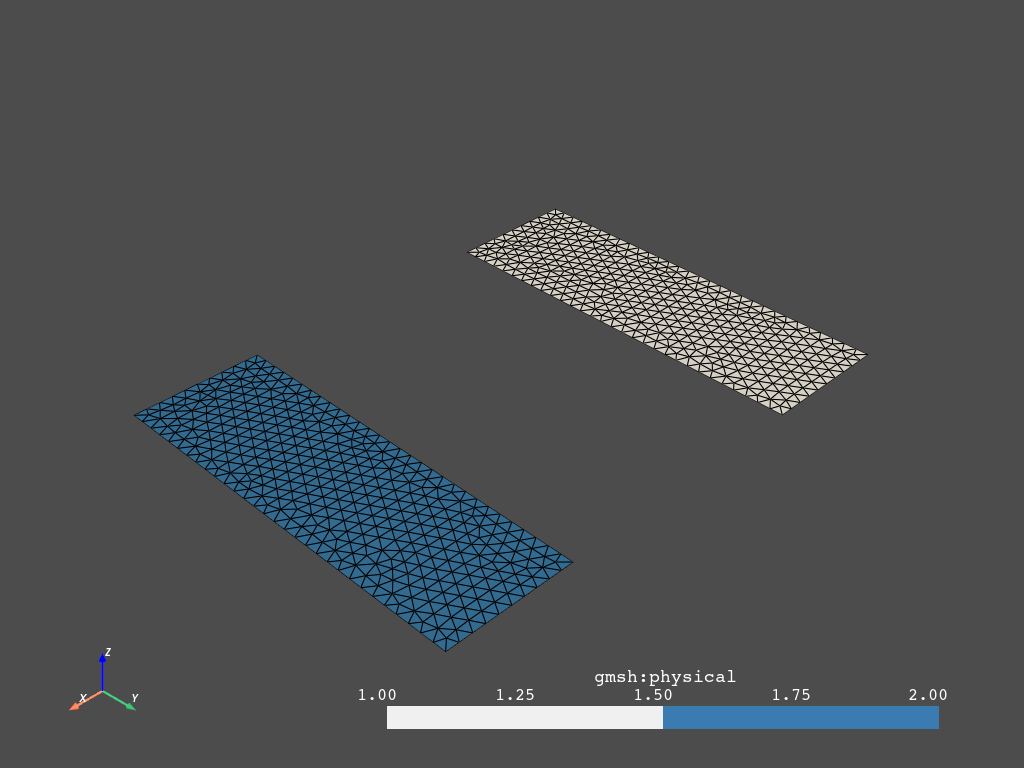
mesh.plot(scalars="gmsh:physical", categories=True, show_edges=True, cmap="blues")
Convert physical groups to Ansys ComponentsNow, here's the trick. Node components need to be bool arrays to for them to be saved to the archive: # the archive reader writer must have node components stored as bool arrays
for group in range(1, 3):
mesh.cell_data[f'GROUP_{group}'] = mesh.cell_data['gmsh:physical'] == groupWrite to an archive using pymapdl_readerarchive_filename = "archive.cdb"
save_as_archive("archive.cdb", mesh)# load in mesh in MAPDL and plot the elements
mapdl = launch_mapdl()
mapdl.clear()
mapdl.cdread("db", archive_filename)
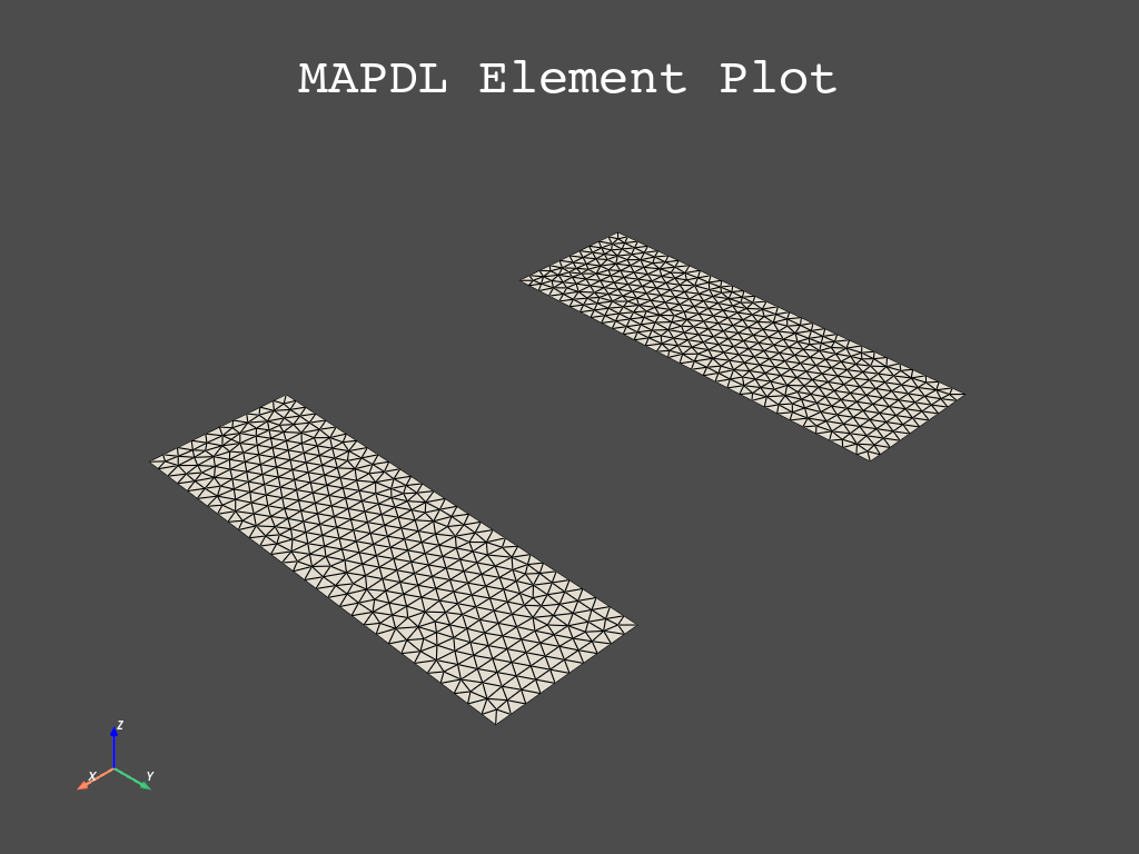
mapdl.eplot()
Show components are indeed loaded into MAPDL>>> mapdl.mesh.n_elem
1448
>>> mapdl.cmsel('S', 'GROUP_1', 'ELEM')
722
>>> mapdl.cmsel('S', 'GROUP_2', 'ELEM')
722
>>> mapdl.allsel()
>>> mapdl.mesh.n_elem
1448If you need ansys-mapdl-reader to support physical groups, ping me and I'll add them. I'm starting to realize how awesome gmsh is and how we should support it better. 18 days late, sorry about that. |
Beta Was this translation helpful? Give feedback.
-
|
Thanks for the help, the physical group selection works perfectly this way! Now the only problem remaining is the nodes getting overridden when importing a second CDB file, as written in my last comment. I tried importing both files using the Ansys APDL GUI, but it also doesn't work. So far the only thing that prevents the second import from overriding the first import seems to be using the |
Beta Was this translation helpful? Give feedback.
-
|
Here's a minimum working example: Create a Mesh Using gmshimport pyvista as pv
from ansys.mapdl.reader import save_as_archive
from ansys.mapdl.core import launch_mapdl
import gmsh
import math
import sys
gmsh.initialize()
gmsh.clear()
# Copied from t1.py...
lc = 1e-2
gmsh.model.geo.addPoint(0, 0, 0, lc, 1)
gmsh.model.geo.addPoint(0.1, 0, 0, lc, 2)
gmsh.model.geo.addPoint(0.1, 0.3, 0, lc, 3)
gmsh.model.geo.addPoint(0, 0.3, 0, lc, 4)
gmsh.model.geo.addLine(1, 2, 1)
gmsh.model.geo.addLine(3, 2, 2)
gmsh.model.geo.addLine(3, 4, 3)
gmsh.model.geo.addLine(4, 1, 4)
gmsh.model.geo.addCurveLoop([4, 1, -2, 3], 1)
gmsh.model.geo.addPlaneSurface([1], 1)
ps = gmsh.model.addPhysicalGroup(2, [1]) # this is just the first area
# create second area
gmsh.model.geo.addPoint(0.3, 0, 0, lc, 5)
gmsh.model.geo.addPoint(0.4, 0, 0, lc, 6)
gmsh.model.geo.addPoint(0.4, 0.3, 0, lc, 7)
gmsh.model.geo.addPoint(0.3, 0.3, 0, lc, 8)
gmsh.model.geo.addLine(5, 6, 5)
gmsh.model.geo.addLine(7, 6, 6)
gmsh.model.geo.addLine(7, 8, 7)
gmsh.model.geo.addLine(8, 5, 8)
gmsh.model.geo.addCurveLoop([8, 5, -6, 7], 2)
gmsh.model.geo.addPlaneSurface([2], 2)
ps = gmsh.model.addPhysicalGroup(2, [2]) # this is just the first area
# must sync geo before meshing
gmsh.model.geo.synchronize()
gmsh.model.mesh.generate(3)
# write the gmsh to disk
filename = "t1.msh"
gmsh.write(filename)
# read in the mesh using pyvista. plot it for fun just to show the physical maps
mesh = pv.read(filename)
mesh.plot(scalars="gmsh:physical", categories=True, show_edges=True, cmap="blues")
Convert physical groups to Ansys ComponentsNow, here's the trick. Node components need to be bool arrays to for them to be saved to the archive: # the archive reader writer must have node components stored as bool arrays
for group in range(1, 3):
mesh.cell_data[f'GROUP_{group}'] = mesh.cell_data['gmsh:physical'] == groupWrite to an archive using pymapdl_readerarchive_filename = "archive.cdb"
save_as_archive("archive.cdb", mesh)# load in mesh in MAPDL and plot the elements
mapdl = launch_mapdl()
mapdl.clear()
mapdl.cdread("db", archive_filename)
mapdl.eplot()
Show components are indeed loaded into MAPDL>>> mapdl.mesh.n_elem
1448
>>> mapdl.cmsel('S', 'GROUP_1', 'ELEM')
722
>>> mapdl.cmsel('S', 'GROUP_2', 'ELEM')
722
>>> mapdl.allsel()
>>> mapdl.mesh.n_elem
1448If you need ansys-mapdl-reader to support physical groups, ping me and I'll add them. I'm starting to realize how awesome gmsh is and how we should support it better. 18 days late, sorry about that. |
Beta Was this translation helpful? Give feedback.
-
|
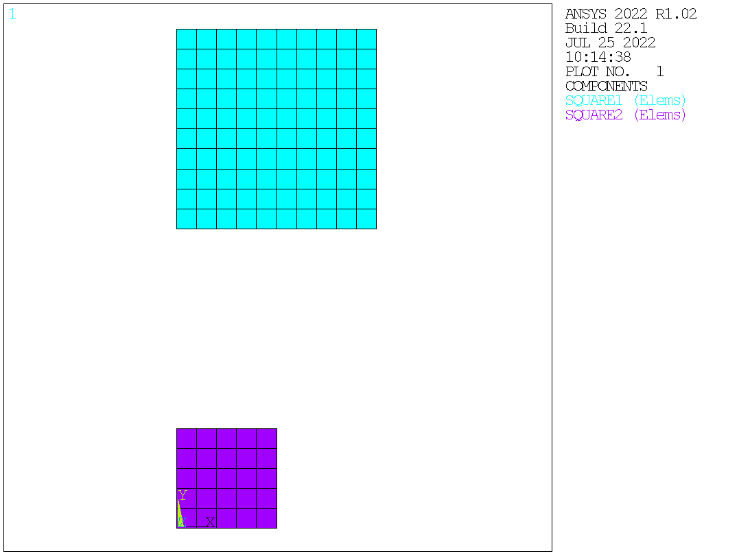
Hi @fzanst @germa89 @akaszynski fzanst sorry the MAPDL help is not clear on this. Usually the cdb file will contain the necessary NUMOFF commands to offset the numbering of the existing FEM so as to fit the FEM contained in the cdb into the model with numbering starting at 1. Looks like gmsh does not write that command to the cdb file. So you would need to add it manually. The NOOFFSET command can bypass NUMOFF. The Clear option does not result in an offset being created. The cdb files have element types, nodes and elements. Whether to offset nodes and elements is usually straight-forward. But element types, materials, real constants, etc may not be. Anyway this will import the two cdb files properly: from ansys.mapdl.core import launch_mapdl
import os
import sys
path = os.getcwd()
mapdl = launch_mapdl(run_location = path, additional_switches = '-smp')
mapdl.clear()
mapdl.prep7()
mapdl.clocal("11", 0, "", "0.15")
mapdl.csys(0)
mapdl.cdread("db", "square1.cdb")
mapdl.transfer("11","","all")
mapdl.cm("square1", "elem")
n_max = mapdl.get_value('node',0,'num','max')
e_max = mapdl.get_value('elem',0,'num','max')
mapdl.cmsel('u','square1')
mapdl.numoff('node',n_max)
mapdl.numoff('elem',e_max)
mapdl.cdread("db", "square2.cdb")
mapdl.cm('square2','elem')
mapdl.allsel()
mapdl.cmsel('s','square1')
mapdl.cmsel('a','square2')
mapdl.show('png','rev')
mapdl.cmplot('all','elem')
mapdl.show()
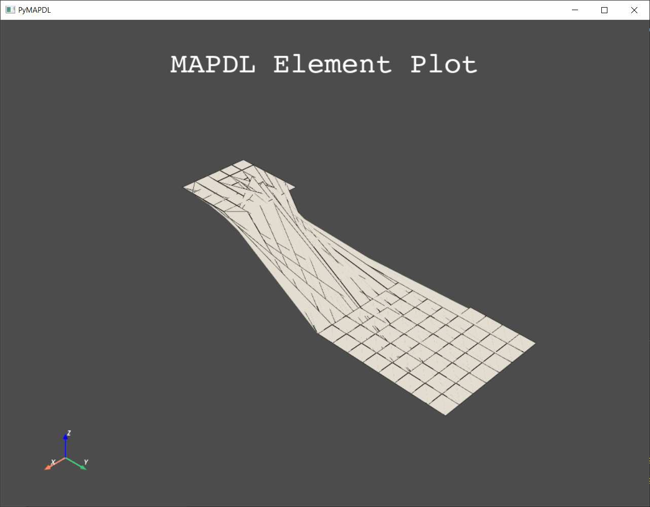
mapdl.exit()The plot should show this: Mike |
Beta Was this translation helpful? Give feedback.
-
|
Amazing, thank you very very much @mikerife |
Beta Was this translation helpful? Give feedback.
-
|
Thanks for the quick reply, Example: Import one has 10 nodes and is offset by 10, meaning its node numbers are 11-20. If the second import has 15 nodes, the nodes of the second import will be 1-15, overriding the first few nodes of the first import (11-15). You can try it by switching square1 and square2 in the As a workaround I am currently reading the number of nodes and elements of the second import from GMSH and using these as offset values, but I was/am looking for a cleaner solution, if one exists. Franz |
Beta Was this translation helpful? Give feedback.
-
|
Hi @fzanst I'd not consider this a workaround, rather just working with the APDL commands as they are. We need to remember that this functionality goes back decades and one assumption was that the cdb files were being generated by MAPDL which auto writes the correct NUMOFF to the cdb file when using CDWRITE. Anyway parsing through a file to find a specific value is a PITA in MAPDL so here is a Python version. I think I could do better with respect to memory usage on accessing the file to find the two specific lines. But it works. The 4th (starting counting at 1) field of the NBLOCK and EBLOCK cdb commands are the maximum node and element number in the block. We can search for these lines; get the 4th field value; then use that as the appropriate numoff. Note that this is still not fully generic as (generally speaking) cdb files can contain N and EN commands to define nodes and elements. A better way would be to: 1 Read in first cdb Anyway here is the updated PyMAPDL script: from ansys.mapdl.core import launch_mapdl
import os
import sys
path = os.getcwd()
mapdl = launch_mapdl(run_location = path, additional_switches = '-smp')
mapdl.clear()
mapdl.prep7()
mapdl.clocal("11", 0, "", "0.15")
mapdl.csys(0)
mapdl.cdread("db", "square1.cdb")
mapdl.transfer("11","","all")
mapdl.cm("square1", "elem")
def lines_that_start_with(string, fp):
return [line for line in fp if line.startswith(string)]
with open("square2.cdb", "r") as fp:
nblock_line = lines_that_start_with('NBLOCK',fp)
with open("square2.cdb", "r") as fp:
eblock_line = lines_that_start_with('EBLOCK',fp)
nblock = ''.join(nblock_line)
eblock = ''.join(eblock_line)
n_max = int(nblock.split(',')[3])
e_max = int(eblock.split(',')[3])
mapdl.cmsel('u','square1')
mapdl.numoff('node',n_max)
mapdl.numoff('elem',e_max)
mapdl.cdread("db", "square2.cdb")
mapdl.cm('square2','elem')
mapdl.allsel()
mapdl.cmsel('s','square1')
mapdl.cmsel('a','square2')
mapdl.show('png','rev')
mapdl.cmplot('all','elem')
mapdl.show()
mapdl.exit()Mike |
Beta Was this translation helpful? Give feedback.
-
|
Thanks a lot Mike! This is now working perfectly, sorry for bothering so much! Franz |
Beta Was this translation helpful? Give feedback.
Hi @fzanst @germa89 @akaszynski
fzanst sorry the MAPDL help is not clear on this. Usually the cdb file will contain the necessary NUMOFF commands to offset the numbering of the existing FEM so as to fit the FEM contained in the cdb into the model with numbering starting at 1. Looks like gmsh does not write that command to the cdb file. So you would need to add it manually. The NOOFFSET command can bypass NUMOFF. The Clear option does not result in an offset being created. The cdb files have element types, nodes and elements. Whether to offset nodes and elements is usually straight-forward. But element types, materials, real constants, etc may not be. Anyway this will import the two cdb fi…