Reprojecting Satellite Image #2616
-
|
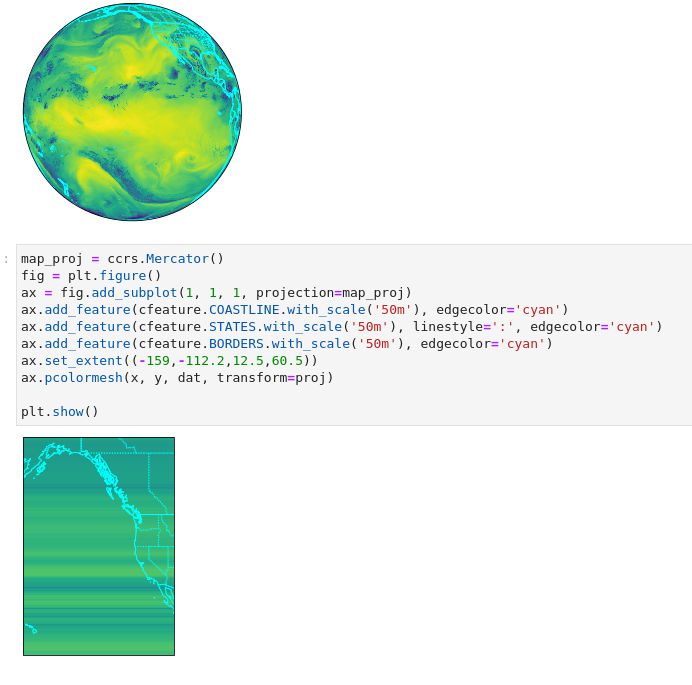
Changing map projections always trips me up, but I thought this would work: import xarray as xr
import metpy
import cartopy.crs as ccrs
import cartopy.feature as cfeature
import matplotlib.pyplot as plt
sat_file = '/nfs/wxdata1/ldmdata/GOES/GOES18/Products/CloudAndMoistureImagery/FullDisk/Channel09/20220815/OR_ABI-L2-CMIPF-M6C09_G18_s20222272030200_e20222272030200_c20222272030200.nc'
ds = xr.open_dataset(sat_file)
ds = ds.coarsen({'x': 2, 'y': 2}, boundary='trim').mean()
dat = ds.metpy.parse_cf('Sectorized_CMI')
proj = dat.metpy.cartopy_crs
x = dat['x']
y = dat['y']
fig = plt.figure()
ax = fig.add_subplot(1, 1, 1, projection=proj)
ax.add_feature(cfeature.COASTLINE.with_scale('50m'), edgecolor='cyan')
ax.add_feature(cfeature.STATES.with_scale('50m'), linestyle=':', edgecolor='cyan')
ax.add_feature(cfeature.BORDERS.with_scale('50m'), edgecolor='cyan')
ax.pcolormesh(x, y, dat, transform=proj)
plt.show()
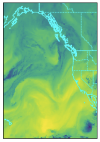
map_proj = ccrs.Mercator()
fig = plt.figure()
ax = fig.add_subplot(1, 1, 1, projection=map_proj)
ax.add_feature(cfeature.COASTLINE.with_scale('50m'), edgecolor='cyan')
ax.add_feature(cfeature.STATES.with_scale('50m'), linestyle=':', edgecolor='cyan')
ax.add_feature(cfeature.BORDERS.with_scale('50m'), edgecolor='cyan')
ax.set_extent((-159,-112.2,12.5,60.5))
ax.pcolormesh(x, y, dat, transform=proj)
plt.show()The first plot does give me a beautiful full disk image, but my attempt to zoom in and display the plot on a Mercator projection does not. I've attached a screenshot showing the results. Is this a MetPy deficiency, or did I miss something? |
Beta Was this translation helpful? Give feedback.
Replies: 1 comment
-
|
No MetPy issue here, since it's only involved in the parsing of the netCDF metadata into the cartopy CRS. Your problem is this call: map_proj = ccrs.Mercator()That's not specifying a map_proj = ccrs.Mercator(central_longitude=-130)I get the expected image: |
Beta Was this translation helpful? Give feedback.
No MetPy issue here, since it's only involved in the parsing of the netCDF metadata into the cartopy CRS.
Your problem is this call:
That's not specifying a
central_longitude, so it uses the default of 0. My guess is using a projection so far from the region of interest/valid range of data causes some weird "seam-crossing" issue. If I instead use:I get the expected image: